
How did I come up with the idea of doing a running trip 2,500 kilometers away from home? Why did I decide to do it beyond the Arctic Circle?
Let me explain. About year ago, I opened the Lofoten Ultra Trail website, saw the pictures, and was totally amazed. What are these Lofoten? Where is it? I have to go there!
So I made a plan. A plan to go there alone, only by myself, with a backpack, and cross the entire archipelago northwards (260 km) in 5 days - while running x32and marching. Later, I also decided to combine this trip with a charity event to raise funds for Dominika - a girl who cannot walk and needs a special NF Walker rehabilitation device.
As for the distance itself, for ultra runners, 260 km in 5 days is not a big deal. Here, however, there were some differences, i.e. lack of any support, backpack weighing about 6-7 kg and a terra incognita - I didn't know the area and the route would not be marked. I started training for the event, running with dumbbells, or even with a kilogram of salt in the backpack, doing a lot of core and back muscle strengthening exercises but even just before the trip I was not sure if I would manage.
But… if I don't try, I will not find out.
So I tried.
Day 1 Å - Skagen (58 km)
I started the journey from Å. The first kilometers were tough. The backpack weighed over 7 kg, because in addition to my tent, sleeping bag, pad, electronics and clothes, I had there a supply of food for 5 days and a water.

On that day I covered mainly asphalt roads. I wanted to cross the mountains without a trail, to reach Kirkefjord but the narrow path quickly ended, and I landed on a steep slope in the bushes. Garmin was going crazy. It showed "you are outside the course", and then "you are on the course", but what a course was that? Probably for mountain goats. I was looking for some logical and safe passage, even climbed on all fours up the hill, catching the tree branches. But then I saw the pass, which I had to cross, covered with snow. After an hour I gave up seeing that my virtual tour drawn in the gpsies.com app was unreal and I came back to the asphalt road to Fredvang. Lofoten vs. Ewa 1: 0.

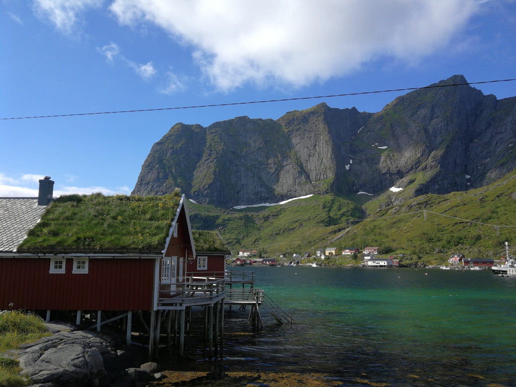
Then it went quite smoothly - running along the road, passing red Norwegian houses, clouds attached to gloomy peaks, the aroma of cod heads hanging on special racks and drying around me. I visited a secret spot - the beatiful Kvalvika beach hidden behind the mountains and headed towards the camping site in Skagen.

Although I traveled alone in Lofoten, I always met someone nice to talk to at every camping site. We were like leaves that the wind brings together for a moment, and then blows away in different directions and everyone goes his own way. In Skagen I met two guys from Poland riding on their bikes from Oslo to Nordkapp.
Day 2 - Skagen - Haukland (52 km)
Every day was a mix of mountains and asphalt, so no boredom. On that day, I first ran along a gravel road in the company of sheep, and then I entered Fiskersti, a path along the cliff leading to Nusfjord, which is a historic route used a hundred years ago by local fishermen. In Lofoten the trails are marked (rarely) on a rock or tree with a red dot (sometimes the letter "T"), and high in the mountains with cairns made of stones.


According to the Fiskersti signpost, it was a "6 km / 2 hours, some sections difficult". Come on, I'll do it much quicker I thought, but soon I learned that they were right. When boulders, rocks, chains and a ladder appeared, I already knew what the Norwegians meant by "difficult".
It took me almost 2 hours to reach Nusfjord. I did not stay there long, because I had another 15-kilometer passage in the mountains ahead of me. I covered that route alone, let alone for two pairs of tourists, who told me that I must be careful, because some sections were difficult and very steep.
The difficult place required some scrambling up, and then descending in similar conditions down. I was so happy that I did some training in the Tatra mountains before the trip, which made my familiar with such places. The Tatras are an ideal training playground for the Lofoten Islands.


The coastal road to Napp was the most beautiful section that I have crossed in Lofoten. In the evening I reached Hauklandstrand, the beach where camping is free, and there is a normal toilet and a tap with water (not potable).
That day, for supper, my kitchen served lyofilized carbonara in a crispy and lukewarm version, because the only water I got was the one heated in a tin by the bonfire made by Poles I met there. I did not take a stove with me from Poland to limit the weight of my backpack. I was not, however, as you can guess, picky.
Day 3 - Haukland - Rystad (52 km)
Morning logistics took time. I kept all my stuff in string bags to protect it from getting wet and every day I had to pack it up so that important things were at hand and nothing hurt my back. On that day, my first goal was the SPAR grocery store where I bought a luxurious small bottle of coke for 3,5 USD. You know - sugar plus caffeine is a priceless mixture for ultra runners, so I invested in that treasure. And then I entered the mountains again and began navigating in loneliness according to my Garmin track and the Locus Maps Pro application. At the top the trail disappeared, and meadows and bushes stretched before me. After about half an hour of roaming and swearing "where the ++@$# is my trail ??"

I started going straight down to the lake without any path and soon my shoes and socks were soaked with water. Suddenly I found the markings of the trail - thin sticks with red tips. I reached the Rystad camping site via an asphalt road and crossed a beautiful and windy bridge separating Vestvågøya and Austvågøya islands.

Day 4 (Rystad - Sandsletta (37 km))
At the beginning of the day, there was a small "earthquake" .... I checked Facebook and saw that the fundraising for Dominica was over because an anonymous person donated 17 thousand zlotys! The fundraising account was 100% full. If there are moments in your life when you feel like flying above the ground, then it was one of them. Then I ran along the Olderfjord. The plan for the day seemed easy - crossing the mountains twice and doing only 37 km. I will finish soon - I thought so!
I knew that the trip from Olderfjord to Svolvaer would be difficult and off-trail, but I was hoping for a path. I decided to take the route of the Lofoten Ultra Trail race from last year, but did not take into account that their route was marked, and mine not. Fjord was like a typical fjord, long as a compression sock, but finally after 5 km it ended, I crossed the river and oops! I landed in the middle of a very swampy meadow. Shoes and socks caught water instantly. I tried to navigate. Well, there must be a path somewhere! There wasn't any. The garmin showed that I was on the right course, but actually I was in deep shit. I went through tall grass, then did some bushwhacking.


Finally I scrambled through some more bushes, ferns and boulders, giving up hope for any path. After crossing the pass, doing a long mountain run with one more climb, I finally reached the city of Svolvaer. It was already before 6 pm, and I had another 15 km to the camping site in the mountains with another mountain pass to cross. I did some quick shopping in Rema 1000 (a bun, coke, and cookies) - the last store before the end of Lofoten and moved on. In Poland, I would not go to the mountains at this Time of day, but here I had the advantage of the midnight sun until morning, so I took up the challenge. First, the trail led through the woods along wooden platforms, until climbing began - 520 m upwards over a distance of 4.5 kilometers.
I was going up feeling a little bit depressed that it was late and my legs were tired. I craved for meeting a soulmate, someone who would support me mentally. And then suddenly I saw a still figure on the rock high above me. It made me happy, whoever it would be - I'd talk and feel better. It was a woman, curled up, with a big backpack, a camera hanging around her neck and trkking poles attached to her wrist. When I came closer to her she suddenly started shouting "CAN YOU HELP ME?"
As she was descending, she made a mistake and went on a slippery rock on which her shoes began to slide. So she sat there and was stuck for an hour or so, waiting for no one knows what. She was in panic and was afraid to move either up or down. We talked a bit, and finally I traversed the rock and gave her my trekking pole to pull her up. We made it! What's next? In the end, she took off her backpack and rolled it down a few meters to cover this difficult section without any weight.


I was alone again and constantly going up. 100% focus on the path or boulders that I traversed. Finally I reached the peak - snow lied there in large patches, clouds were everywhere and the wind was blowing. A quick pair of photos and I decided to run away from this moon-like area.
There was a path along the lake there. Just don't look down! Focus on the path or it will disappear again! - I was running along the traverse of a steep slope. 10 meters below me, there was the black and devil knows how deep surface of Lake Botnvatnet. Finally, I descended to the forest and felt relieved to return to civilization. I reach Sandsletta camping site after 10 pm - that would be it as for a shorter running day on my trip.
Day 5. Tip (Sandsletta - Raftsund (53 km))
After yesterday's mountain passage, I welcomed the E10 road. I was running all flat and down sections and marching quickly uphill. Where did I still have so much strength from? I think it was in my head. I crossed one more mountain pass to get to Morfjorden, and then only asphalt and gravel roads were awaiting me, but this was the only option.
I was a little bit sad that it was the last day of my adventure, but at the same time I was so glad that I arrived here. I could not wait to see the Raftsundbrua bridge separating Lofoten from the islands of Vesteralen, which was the goal and the finish line of my trip. And there it appeared finally - I saw it rising majestically over the strait. After 5 days I had almost 260 km in my legs. I did not have anyone to celebrate with, so I recorded a movie and called Hurray! to myself. And then I had to go another 4.5 km to the camping site, to sleep and take a shower.


Return
In the night it started to rain and it was the first rain on my trip. Wearing a rain poncho I tried to hitchhike to come back to Moskenes ferry harbour, but nobody stopped for like 40 minutes. Finally, I came up with an idea to take off this clothing, because I might have looked like the protagonist of the Hitchhiker horror movie. Bingo! After a minute a car stopped and friendly Norwegians gave me a lift as far as 75 km to Borge, and then a nice girl brought me straight to Moskenes. I spent my last night in Lofoten in a bathroom-sized ferry waiting room, but at least it was free and dry, and in the morning I embarked the ferry to Bodø.


Summary
Lofoten. Ultra.Solo - my idea and dream came true! I did it - partly running and partly marching. The charity fundraising was a huge success as well. Lofoten are wild and insanely beautiful. I visited quite a piece of them, not just the most tourist places, but the hidden gems, which are hard to reach from parking lots where you leave your rent-a-car. I recommend such trip beyond the Arctic Circle to everyone. What's more I got a present from the weather - the temperature was perfect for running with a mixture of sun and clouds.
My body endured the expedition better than I thought. Yes, my gluteal muscle ached, but two painkillers did the job, and I had no serious injuries, foot chafes or wounds. Of course I was tired - in the evenings I reached the campground dreaming only of lying down in my tent. However, during the days my head was so focused on the task that I didn't think about fatigue. I felt really exhausted only in Bodo, two days after the whole event - as if all my adrenaline and energy left my body and mind. As you can imagine, now I am planning a new trip to a different place because as my friends warned me - once you do such thing, you just want more and more.I think it will be Cornwall :)
Incredibly beautiful pictures and really helpful piece of writing.! It's really an absolute delight to watch your clicks.
OdpowiedzUsuńThanks for sharing!
embroidery patches for clothing
Back patches for clothing
Hi, thanks for such nice words! Great that you enjoyed it, and if you are into fastpacking or light backpacking I can also prepare the English version of my post about preparations for such trip with lots of specific information about gear, food and other stuff. Cheers!
OdpowiedzUsuń