
After my last year's fastpacking trip beyond the Arctic Circle, to the wild Lofoten, this year I chose a completely different place for a running adventure.
A place with a milder climate, often called the British Cote d'Azur, hashtagged on instagram as #kernowfornia - the South West Coast Path in Cornwall.
Palm trees, crystal blue water, sunny cliffs - that's how I saw it in my imagination and on the photos. I even thought for a moment that maybe I was taking a soft option with this trip after the dark northern Norway. Hahahaha!

The length of the entire SWCP trail is 631 miles, but I only wanted to cover the Cornish section of this route. It was supposed to take me 9 days and about 290 miles. I considered it doable - less miles on the first two days, then participation in the R.A.T race, and then pushing as hard as I can. And this is how it actually looked like, with an emphasis on "pushing as hard as I can".
During the preparations, I got many signals both from the SWCP descriptions and correspondence with local runners with whom I made contact. In general, I had to prepare for many ups and downs. And the closer it was to the trip, the more I was scared.
A few days before the start, after a hundredth analysis of elevation and weather forecasts, I experienced a phase of denial and negation. Butterflies in my stomach. I don't want to go there, it will be hard as hell... , I didn't train enough, I can't do it. That's what my intuition told me. But, on the other hand, my Facebook eco-task game was invented, my ticket bought, a set of running and core workouts done. I had to move!
After travelling from Warsaw to Plymouth, I spent the first night in a hostel. In the morning, a nice elderly gentleman, after hearing the plan of my trip, handed me a ziplock plastic bag so that I could keep the phone there and protect it from rain. It was the key bag at this trip.
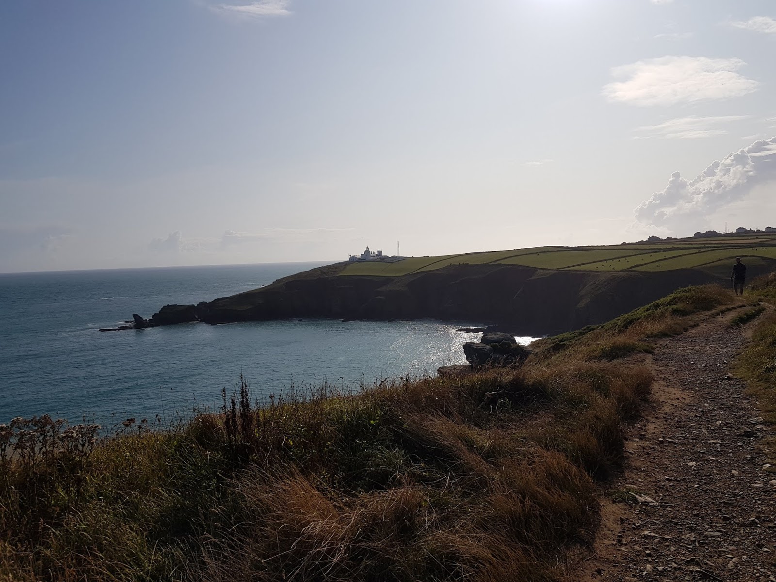
Day 1. Cremyll - Polperro 27 miles (+4156 ft)
I start with a ferry crossing to the other side of the river. There is the first wooden "Coast Path" sign and I get emotional. So this is really happening, I will be following these signs towards Bude for the next 9 days. Ready, steady, go! Despite a relatively easy terrain, the run is difficult at first, this backpack with 7-kilo content is not yet a part of me. It will become one in a few days.


I run or power hike up the hills with my poles, recognizing the places that I have seen so many times on the map. Ok, so this is Rame Head. And that's the shooting range. I fix backpack straps and suddenly, one breaks. Well, a nice start! Fortunately, this is only a side strap, so I tie it somehow and run. I am surprised by how often I have to squeeze through stiles. During the whole trip I probably went through hundreds of them.

Finally, with a marathon in my legs I reach Polperro and here we have the first rain. The road to the campsite leads sharply uphill, so I am walking slowly and getting there in a nice downpour and fog. The campsite is just a field with a few tents and a toilet/shower building.

I put up my tent in the rain and it gets wet immediately, because I got out of practice with putting it up fast, so I run away to the shower building and wait for the rain to stop. There appears a plan in my head that if it doesn't stop, I will sleep there. It smells a bit, but it's a minor problem, because there are "luxuries" inside - a hand dryer (I dry up clothes under it), socket, clean corridor and a bathroom with lukewarm water. The lyophilized food with such water crunches in my teeth, but I'm not picky.
So I camp there, and whenever someone enters, I ask if it is ok with them if I sleep on the floor in that building. Nobody protests. And then, I experience the first kind gesture from a stranger. A nice English woman brings me a kettle, tea, coffee, cookies, milk and chocolate. It's jaw dropping!
I feel a little like a homeless sleeping on the floor next to the toilet, but at least it's not raining there.
Day 2. Polperro - Porthpean 18.5 miles (+3087 ft)
In the morning I set off to the cliff, a high one with big exposure and after a quarter of an hour it begins to pour. And in a moment it gets very windy too. There is nowhere to hide, so I put on my plastic poncho and keep pushing, dripping and with spray on my face. The wide poncho flies around me. This element will need to be refined next time.


Luckily I have all important items hidden in plastic, ziplock bags. Yes, I know #noplastic is fantastic, but how to protect your stuff from rain in eco bags? The wind is so strong that I finally run away from the cliff to a local road 1,5 mile before Polruan. Then it clears up a bit and here comes the sun making the views really amazing.
This is a short running day. Tomorrow I have my race. I'm already close to the race office and campsite in Porthpean, it's raining again, so I install myself in a Charlestown bar, which has wifi and wait for the campsite's gates to open.

During the night it's raining and blowing again. Poor competitors of the 100 km "Plague" race who started at midnight and a group of "madmen" from BOYD who will run for 24 hours on a 5 mile loop with a 350 m elevation gain.
Day 3. R.A.T. - St. Anthony Head - Porthpean 32 miles (+6050 ft)
This race seems a bit against common sense for me. First of all, the 32 mile route runs through the Coast Path, but in the opposite direction than my trip (they bus us and we have to go back to Porthpean), secondly it is probably not the best idea to compete in a race when I have over 180 miles to go in next days. But common sense is boring! I meet cool people, I run a beautiful route with a race number attached to my leggins - that's what ultrarunners like the most.


I am aware that in this way I have also eliminated the possibility of calling my trip a total self-support event because I leave my backpack for the time of the race, and enjoy food and drinks at the checkpoints. But it's worth it! The route is beautiful, in the second part it is hard as hell and although I don't push to the maximum, I reach the finish line with killed quads and calves after 7 hours. As it turns out later, I was 6th out of 81 in my gender category.
Sadly, in the evening, instead of partying, I take down my tent and get a ride with nice people to Falmouth, from which I have to start the next morning to continue the trip. I sleep in an airbnb room at an interesting lady who tells me how she climbed oil rigs in Greenland with other Greenpeace activists to occupy them, for which she was arrested and kept in a Danish prison.
Day 4. Falmouth - Mullion Cove 39 miles (+6069 ft)
Sunny Cornwall! Today you are almost like the Cote d'Azur! I have sunshine, beautiful views and even quite fresh legs. However, the freshness disappears gradually with the next miles because easy terrain turns into strangely difficult, with stairs, boulders and ascents that require the use of hands. In addition, I start to feel pain in my right leg above the ankle. Oh no! Just not this! I can't finish the trip after 4 days.


In the evening, after more power hiking than running I get to the southernmost tip of Great Britain, a crowded Lizard Point, from where I have 5 miles to reach the campsite on the cliff top. Soon tourists disappear, and it's only me galloping with my backpack through the grassy paths alone looking at the beautiful sunset.
At the campsite, I again meet nice and helpful people. A family with a big tent next to mine invites me for a cup of tea, and gives boiling water for my lyo food.
This is the night when it starts raining again and I find out that my tent ... is not waterproof, because at 5 am a drizzle on my face wakes me up. Oh no! My down sleeping bag! I pull my sleeping pad from underneath myself and cover the bag with it for protection. And later I have to dry up this damn sleeping bag in the bathroom under a hand dryer, which takes almost an hour.
Hello! I need to make extra miles in the morning because (sorry boys!) I get my period long ahead of schedule and I have to buy women's hygiene products in a nearby town. Damn it! I think that it is the effort and climate change that cause such anomaly. Anyway I am a bit pissed off that I have to make a diversion to Mullion.
Fortunately, the leg pain is gone, and the weather is great. I run along dry beautiful cliffs, of course every now and then descending the stairs just to cross a small bridge and climb up the hill again. That's the nature of the Coast Path. I pass beaches and colorful flowery meadows with stone chimneys - remains of local mines.


Finally, I reach Marazion with its beautiful St. Michael Mount. There is a walkway that you can use to get to the castle at a low tide. I am at a high tide there, so I only watch it from a distance. Anyway, I don't have spare time because I have to reach the campsite by 9 pm. They don't accept newcomers later.
After a long and flat section through Penzance, where I run as fast as I can, the Path shows me its wilder side in the evening. Up and down again. And the cliff near Lamorna is only boulders, rocks, stairs, mud, not runnable at all. But I have to push because they won't let me into the campsite. I reach Treen 20 minutes before the "cut-off".


A drizzle comes when I start putting up my tent, and at night ... of course it starts raining heavily. The tent is leaking again. I wrap my backpack in the poncho, and at 4 am I move with my sleeping bag and pad to the laundry and shower building, where I lay myself down on the floor right after preparing a message for night visitors of this place. "Sorry that I am sleeping here but my tent is not waterproof".
Day 6. Treen - Carbis Bay 34 miles (+6068 ft)
After 6 am, I hear a noise and I see a mop and a bucket. Cleaning service has just entered. "Sorry that I am sleeping here but ...".
That's ok! says the lady and she calmly mops around me. I eat my breakfast and prepare to set off. There is a puddle in my tent so I wipe it with paper and pack the dripping sheet into a cover. Let's go and reach Gwithian in the evening.
The morning is chilly but that's OK because I am not thirsty. I know from locals that I have an interesting but quite difficult section ahead of me, especially near Zennor, and I will have no access to water for ca. 13 miles. It's a bit worrying but I'm happy that I will enter the north coast at the end of the day.
Run, climb up, climb down the stairs, repeat. God, what would I do without my trekking poles! Sometimes I pass runners, going light, with running vests. And I'm like a camel. Well, I envy them a little, but my backpack is becoming less and less onerous. I've got used to it. I pass the crowded Land's End - the westernmost end of the Great Britain. Then, a nice Sennen Cove, where I refill water in the ladies toilet and eat the traditional "Cornish Pasty" with cheese and vegetables. It gives me power!
In Zennor I don't have any more water. Damn it! My navi shows that there is a cafe in town so I add an extra 1,5 mile, buy coke and get tap water for free. I'll be fine! I'm doing well, what's the fuss about that Zennor path. But soon I realize what's going on here. There is no scrambling or dangerous sections, but the run turns into never-ending ploughing through stones, boulders and bushes. Not runnable at all.


The chances of getting to the campsite are getting smaller and smaller because I'm moving so slowly. Finally this massacre is over and I see a beautiful coast of St. Ives. It will be dark in an hour. What to do, where to sleep? The tent is wet inside out, my clothes too. I am looking for an airbnb - there are some ... for 120 GBP. Available B&B - similar price. Damn it! I keep going, maybe I will find something along the way. But it's getting dark and I haven't found anything in Carbis Bay. Well, I will not sleep on the bench, especially since it is supposed to rain at night. Finally, all in mud and smelly, I find a place in a B&B where a nice gentleman with a nice smile ruthlessly charges me 90 GBP! I know it's crazy, maybe I should have camped wild. Rain is just water anyway. To console myself I try to enjoy the fact that I have breakfast included and an elegant white dressing gown that I am afraid to touch before the shower. The tent is still wet, there is nowhere to unfold it.
Day 7. Carbis Bay - beach in Crantock on the Gannel River 37 miles (+5183 ft)
I open the curtains. Fuck! It's raining and howling. Palms are bending. During breakfast, I prepare my head for the next day, I lubricate my feet with an extra layer of SecondSkin and set off. The path goes through the bushes so after a quarter of an hour I'm all soaked. My foot hurts because I got a big blister there and another one on the heel. Today is a day of sand in my shoes, because the Path leads through beaches at resorts and quite a lot through dunes, especially towards the end of section near Perranporth. Every now and then I stop to dump out sand, wring my socks and lubricate my feet, but it's a never-ending story.

The beaches here are beautiful - wide and white, with dozens of surfers, stuck in the water like seals side by side in anticipation of a good wave. It doesn't rain anymore, it only blows strongly. I run fairly quickly through the dunes in the evening because I know that today I will also sleep under a roof. Another great gesture from a local man, namely, Fergy, the race director of R.A.T., who offers me accommodation, where I can rest a bit, wash my smelly clothes and, above all, dry up my tent. People are soooo nice to each other here, it's unbelievable!
Day 8. Newquay on the Gannel River - a cliff behind Port Gaverne 40.5 miles (+6064 ft)
Cliffs seem to be higher here. And they still have stairs. Moving along the Coast Path looks to a large extent like this: you are on the 12th floor of a skyscraper and you have to go down to the ground floor, and then, after crossing a bridge, you make an ascent to the 12th floor again. But it doesn't impress me anymore. Nothing special now!


The forecast is good for today, so I have to keep going ahead, although I know I'm behind my plan. I didn't get to Gwithian the day before and I won't reach Tintagel today because it's just too far and too difficult. I can't help it. I am on my feet every day for about 11-12 hours, without spare time to sit down, relax and enjoy the views. My pitstops are only technical - refill water, eat an energy bar, dump out sand, connect the power bank, take a photo.
I would appreciate one more day. Spreading the trip into 10 days would give me a lot more comfort. Maybe I could rebook the ticket for a day later? Nooo, it will probably be expensive, I'm broken after the Carbis Bay B&B :) and I've been away from home for such a long time already. I will push - according to the original plan, to Bude - the last city on the Cornish Coast Path.
I am tired, my feet are sore, my calves are like stones, and the number of blisters is increasing - it is already 5. Finally in the evening I reach Port Isaac. There is no campsite so I will wild camp. Shops are closed so after buying a bag of chips and water in a takeaway I ascent another cliff walking towards Tintagel, to get as far as I can before it gets dark. The forecast for tomorrow is horrible.
Finally, I find a flat square "pitch" hidden behind the bushes, near a pasture, with lots of dry cow shit on the ground. The perfect housekeeper Ewa sweeps it all away with a stick, until the place is reasonably clean and puts up a tent. A hotel under million stars with a sea view. I fall asleep praying that the cows do not come here and nibble on my tent or defecate on it. It starts raining at 2 am but then it stops.

Day 9. Cliff behind Port Gaverne - Millook 25 miles (+4832 ft)
The alarm clock rings at 5:40. It's my last day! I have loads of motivation and joy that I got as far as here. But what a hardcore are these cliffs! Here they are already 100 meters high, and later they will be 200 m above the sea level. And of course stairs up, stairs down. After less than an hour it begins to pour and blow like crazy.
My shoes are soaked, I am wet all through, but well, still trying to stay Zen. The pity is that in this weather, somehow I don't feel like nor do I have time to see the King Arthur's castle of Tintagel. But near the castle I get to the hostel because I have to recharge my phone to have navi. I get coffee for free and enjoy the heat and dryness for about 30 minutes. And then back to the Path in a wet jacket, heavy wet backpack, and wet, slippery shoes. The worst, most difficult Coast Path sections are ahead of me.
When I get to Boscastle all I dream about is a hot tea! I actually buy a cream tea - have to try this second Cornish specialty after the Cornish Pasty. So I eat this caloric bomb while charging my phone.

Staff advises me against going on the Path in these conditions saying it is dangerous. I promise I'll be careful and I'll disappear. After all, I have to reach Bude today, hitchhike, and get to Barnstaple in the evening, because tomorrow I a have flight back to Poland. Tight schedule.
The wind is blowing stronger now. The rain is pouring more heavily as well. I enter Beeny Cliff, pass the Optional route signpost and trot along the Coast Path. After a while I realize that something is wrong here, something is different. Yes, I'm on a very narrow path traversing the cliff slope, and nothing protects me from falling down straight to the sea. In addition, I have a lateral wind knocking me down towards rocks and water. I suddenly realize that I'm in a deep shit. One strong gust and I'm gone! My heart is pounding, I'm grabbing whatever I can, like grass (hehehe!) and looking for a way to escape. Unfortunately, from the side of the cliff top there is only a fence with three barbed wires along its length. I will tear my clothes or even get stuck there. Oh God, I have to turn back, ca. 220 yards. I am crying, I'm scared because nobody will ever find me here if I fall.
 |
| Beeny Cliff - http://macadder.net/walking/south_west_coast_path/stage45.html |
On soft legs I finally reach the Optional route sign and I'm relieved to escape the Coast Path. I will not die!
What follows, is unfortunately a series of failures. I pound straight across a wheat field to a local parallel road, but I pass it and move farther inland. I am so wet that I have nothing to wipe my rain-flooded phone and the screen stops responding to my touch. I am looking for roads, asking whoever I can for directions but the next hours I'm running blindly in the rain. Some drivers I'm waving to for directions don't stop at all. Very poor chances for hitchhiking in the evening, I think. Finally, after 3 hours, I knock in desperation on some house door asking for something to wipe the phone and a for a dry plastic bag.
Imagine that. A soaked, mud-covered woman asking for a paper towel and a bag in the downpour. The older couple living there is very nice. They tell me that I have 6 miles of a road winding up and down towards Bude, and that I will have a problem with hitch-hiking in such weather. And I won't make it to catch the last bus to Barnstaple, even if I run quickly non-stop. They offer me a ride to Bude.
This is the critical moment when I have to make a quick decision - push forward and reach Bude without a chance to hitchhike or surrender and get there in that nice man's car.
Game over! I give up, I just don't have the strength to run for the 8th hour in the rain with my back chafed and sore, massacred feet and a good chance that the phone with navi will fail again.
So my trip ends 6 miles before the originally assumed destination. At some point in time, I thought that maybe I would reach the Cornish border, Marsland Mouth, but it is an absolutely secluded place, in the middle of nowhere, from where you have to walk another 4 miles towards a larger road that no one may drive in the evening. It wasn't supposed to be this way, but life has shown that not everything can be planned from A to Z.
****
Generally, despite such ending, despite the rain and adversities I am happy and fully satisfied with the trip. I ran and hiked along almost entire Cornish Coast Path. I covered a beautiful and at the same time so damn difficult route I have never walked or ran before. The Coast Path is simply a beauty and a beast in one. I found physical and mental strength somewhere within me to do it every day for 9 days. I embraced pain, accepted difficulties. I was amazed to see all these beautiful places in Cornwall. I reached as deep as possible to my resources. Or maybe not really to the very bottom, you never know.
I met wonderful people, I experienced their selfless kindness. The Facebook eco-fun game I came up with also went well. And one thing is certain - if I were to mention one thing I regret about this trip, I would answer NONE! What was beautiful and nice was a reward, what was difficult and painful was a lesson for me. I came out of this stronger and more self-conscious. And I want more!
ps. A day later, my plane from Bristol to Amsterdam takes off with a 45-minute delay. Despite the crew's assurances that I will succeed to make the connection, I do not manage to catch the flight to Warsaw. I go to the KLM customer service point, where they assign me a hotel and rebook my ticket for the next day ...Curtain drops!

Oh wow! That's very interesting!
OdpowiedzUsuń